


Tamil Nadu Board 10th Standard Social Science - Geography Unit 1: Book Back Answers and Solutions
This post covers the book back answers and solutions for Unit 1 – Geography from the Tamil Nadu State Board 10th Standard Social Science textbook. These detailed answers have been carefully prepared by our expert teachers at KalviTips.com.
We have explained each answer in a simple, easy-to-understand format, highlighting important points step by step under the relevant subtopics. Students are advised to read and memorize these subtopics thoroughly. Once you understand the main concepts, you’ll be able to connect other related points with real-life examples and confidently present them in your tests and exams.
By going through this material, you’ll gain a strong understanding of Geography Unit 1 along with the corresponding book back questions and answers (PDF format).
Question Types Covered:
- 1 Mark Questions: Choose the correct answer, Fill in the blanks, Identify the correct statement, Match the following
- 2 Mark Questions: Answer briefly
- 3, 4, and 5 Mark Questions: Answer in detail
All answers are presented in a clear and student-friendly manner, focusing on key points to help you score full marks.
All the best, Class 10 students! Prepare well and aim for top scores. Thank you!
Unit 1: India – Location, Relief and Drainage
I. Choose the correct answer.
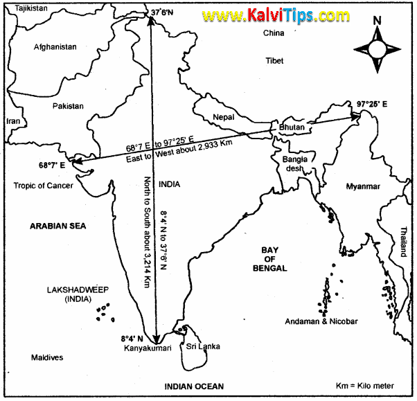
a) 2,500 km
b) 2,933 km
c) 3,214 km
d) 2,814 km
Answer Key:
c) 3,214 km
a) Narmada
b) Godavari
c) Kosi
d) Damodar
Answer Key:
c) Kosi
a) Coast
b) Island
c) Peninsula
d) Strait
Answer Key:
c) Peninsula
a) Goa
b) West Bengal
c) Sri Lanka
d) Maldives
Answer Key:
c) Sri Lanka
a) Ooty
b) Kodaikanal
c) Anaimudi
d) Jindhagada
Answer Key:
c) Anaimudi
a) Bhabar
b) Tarai
c) Bhangar
d) Khadar
Answer Key:
a) West Bengal and Odisha
b) Karnataka and Kerala
c) Odisha and Andhra Pradesh
d) Tamil Nadu and Andhra Pradesh
Answer Key:
d) Tamil Nadu and Andhra Pradesh
II. Match the following.
|
1
|
Tsangpo
|
Tributary of River Ganga
|
|
2
|
Yamuna
|
Highest peak in India
|
|
3
|
New alluvium
|
River Brahmaputra in Tibet
|
|
4
|
Mt. Godwin Austen (K2)
|
Southern part of East Coastal
Plain
|
|
5
|
Coromandel Coast
|
Khadhar
|
|
1
|
Tsangpo
|
River Brahmaputra in Tibet
|
|
2
|
Yamuna
|
Tributary of River Ganga
|
|
3
|
New alluvium
|
Khadhar
|
|
4
|
Mt. Godwin Austen (K2)
|
Highest peak in India
|
|
5
|
Coromandel Coast
|
Southern part of East Coastal
Plain
|
III. Give Reasons.
1. Himalayas are called young fold mountains.Answer Key:
1. Himalayas were formed a few million years ago due to folding of earth crust as a result of tectonic activity.
2. North Indian Rivers are perennial.
Answer Key:
1. North Indian rivers are perennial because they originate in the Himalayas (i.e. snowfed Himalayan glaciers).
2. They receive water during rainy season and during summer because of melting of ice.
E.g : Indus, Ganga, Brahmaputra
3. South Indian rivers are east flowing.
Answer Key:
1. The topography in South India has a slope towards the East.
2. The rivers originate in the Western Ghats and flow to East.
E.g : Mahanadi, Krishna, Kaveri
IV. Distinguish between the following.
1. The Himalayan Rivers and Peninsular Rivers.Answer Key:
|
Himalayan rivers
|
Peninsular rivers
|
|
Originate in the Himalayas.
|
Originate in the Western
Ghats.
|
|
Long and wide.
|
Short and narrow
|
|
Perennial
|
Non Perennial
|
|
Suitable for Hydro power
generation.
|
Not suitable for Hydro power
generation.
|
|
Useful for Navigation
|
Not suitable for Navigation
|
|
E.g.: Indus, Ganga,
Brahmaputra
|
E.g.: Godavari, Krishna,
Kaveri.
|
Answer Key:
|
Western Ghats
|
Eastern
Ghats
|
|
Western Ghats form the Western
edge of peninsular plateau.
|
Eastern Ghats form the Eastern
edge of peninsular plateau.
|
|
They run parallel to Arabian sea
coast.
|
They run parallel to Bay of
Bengal coast.
|
|
Continuous mountain range.
|
Discontinuous mountain range.
|
|
Anaimalai is the highest peak.
|
Mahendragiri is the highest peak
|
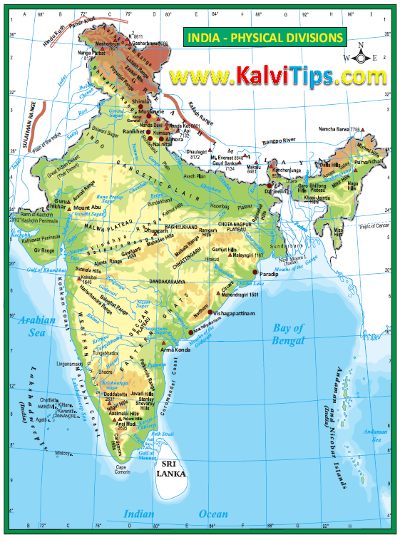
3. Western Coastal Plains and Eastern Coastal Plains.
Answer Key:
|
Western Coastal Plains
|
Eastern Coastal Plains
|
|
It lies between western ghats
and Arabian sea.
|
It lies between Eastern ghats
and Bay of Bengal.
|
|
Extends from Rann of Kutch in
North to Kanyakumari in South.
|
Extend from West Bengal in North
to Tamil Nadu in South.
|
|
It is Known as Konkan Coast and
Malabar Coast. |
It is Known as Northern Circars
and Coromandel Coast.
|
|
Vembanadu is the important lake.
|
Chilika is the important lake.
|
V. Answer in brief.
1. Name the neighbouring countries of India.Answer Key:
1. Pakistan
2. Afghanistan
3. Nepal
4. China
5. Bangladesh
6. Bhutan
7. Srilanka
8. Myanmar.
2. Give the importance of IST.
Answer Key:
1. India extends from Arunachal Pradesh in the east to Gujarat in the west. The longitudinal difference is about 30º.
2. Since sunrises 2 hours earlier in Arunachal Pradesh than Gujarat, a standard time is essential.
3. The local time at the Central Meridian is calculated as the standard time of India.
4. It is 82º 30’E longitude and passes through Mirzapur. It bisects the country in terms of longitudes. The IST is 5’ - 30” hours ahead of GMT.
3. Write a short note on Deccan Plateau.
Answer Key:
1. The triangular Deccan plateau is the largest of the plateau region in India.
2. It is bounded by Western Ghats in the West, Eastern Ghats in the East and Satpura hill range in the North. It has about 7 lakh sq. km area.
3. The height ranges from 500m to 1000m above mean sea level.
4. It slopes from west to east.
4. State the west flowing rivers of India.
Answer Key:
1. Narmada
4. Sharavati
5. Sabarmati.
5. Write a brief note on the island group of Lakshadweep.
Answer Key:
1. Laccadive, Minicoy and Amindivi were renamed as Lakshadweep in 1973.
2. It is a small group of coral Islands off the West coast.
3. It has 32 sq. km. area. Its capital is Kavaratti.
4. ‘Pitt Island’ is a bird sanctuary in Lakshadweep.
VI. Answer in a paragraph.
1. Explain the divisions of Northern Mountains and its importance to India.Answer Key:
1. The Northern Mountains has three divisions.
2. The Trans - Himalayas - The Himalayas - Eastern Himalayas or Purvanchal Hills.
The Trans - Himalayas:
1. It lies to the north of the greater Himalayas range and also Tibekan Himalayas
2. It is known as Western Himalayas.
3. It contains Zaskar, Ladakh, Kailash and Karakoram ranges.
3. It is 40 km wide in the East and West and 225 km in the central part.
4. Lies between Jammu and Kashmir and the Tibetan plateau.
The Himalayas :
1. It has the core part of northern mountains.
2. It is an young fold mountain.
3. Formed by the movement of Eurasia landmass in the north and Gondwana land mass in the South.
India - Location, Relief and Drainage 147
4. Its three main divisions are the Himadri, the Himachal and the Siwaliks.
Himadri (Greater Himalayas)
1. It is 25 km wide and about 6000 mts average height.
2. Contain peaks - Everest, Kanchen Junga.
3. Receives less rain fall.
4. Always covered with snow.
5. It has important glaciers like Gangothri, Yamunothri and Siachen.
Himachal(The Lesser Himalayas)
1. It is 80 km wide and height varies from 3700 to 4500 mts..
2. Contain slate, lime stone and quarzite rocks.
3. Important hill stations like Shimla, Mussourie, Nainital, Almora, Ranikhet and
Darjeeling are found here.
Siwaliks (Outer Himalayas)
1. Extend from Jammu and Kashmir to Assam.
2. The altitude is from 900 - 1100 mts.
3. Contain debris brought by Himalayan rivers.
4. Width ranges from 10 km in the East to 50 km in the West.
Purvanchal Hills:
1. These are the Eastern offshoots of Himalayas.
2. Extends in North Eastern states of India.
3. All the hills are collectively called purvanchal.
4. Dafla hills, Abor hills and Naga hills, Khasi hills and Garo hills are some of the important hills.
Importance of Himalayas:
1. It blocks South west monsoon winds and causes heavy rainfall to North India.
2. It forms a natural barrier to the sub - continent.
2. It is the source of many perennial rivers like Ganga, Indus, Brahmaputra etc.
3. Because of natural beauty, it is called as ‘Paradise’ of tourists.
4. Contain many hill stations and pilgrim centres like Amarnath, Kedarnath, Badrinath and Vaishnavidevi temple.
5. It provides raw material for many forest - based industries.
6. It prevents cold winds blowing from Central Asia and protects India from severe cold.
7. Renowned for the rich bio - diversity.
2. Give an account on the major peninsular rivers of India.
Answer Key:
1. The rivers of South India are called the peninsular rivers.
2. These rivers are non - perennial in nature.
3. Not perennial in nature.
4. Some are west flowing and some are East flowing rivers.
East flowing rivers:
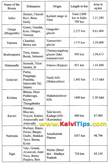
Mahanadi:
1. It originates near Sihawa in Raipur district of Chattisgarh.
2. It flows through Odisha.
3. It is 851 km long with tributaries Seonath, Telen, Sandur and Ib.
4. It empties its water in Bay of Bengal.
5. The delta of Mahanadi is one of the largest deltas in India.
Godavari:
1. It is the longest of the peninsular (1465 km) rivers.
2. It originates in Nasik district of Maharashtra.
3. It is also called “Vridha Ganga”.
4. Flows through Telangana and Andhra Pradesh.
5. Purna, Penganga, Pranitha, Indravathi, Tal and Salami are tributaries.
6. Kolleru, a fresh water lake is located in the delta region.
Krishna:
1. It originates at Mahabaleswar in the Western Ghats.
2. Second largest in the Peninsular rivers.
3. Bhima and Tungabhadra are the tributaries.
4. Flows through Andhra Pradesh and empties in Bay of Bengal.
Kaveri:
1. It originates at Talaikaveri in Kodagu hills in Karnataka.
2. Its 805 km long and is called Dakshin Ganga.
3. Bhavani, Noyyal and Amaravathi are the tributaries.
4. Hogenakkal falls is on the river.
5. It empties into the Bay of Bengal at Poompuhar.
West flowing rivers:
Narmada:
1. It originates in Amarkantak plateau in Madhya Pradesh at a height of about 1057m, and 1312 km long.
2. It covers an area of 98,796 sq. km.
3. Burhner, Halon, Heran, Banjar, Dudhi, Shakar, Tawa, Banna and Kolar are its tributaries.
4. It forms an estuary of about 27km long, drain into Arabian sea through Gulf of Cambay.
5. It is the longest among the west flowing peninsular rivers.
Tapti:
1. It originates near Multai in Madhya Pradesh.
2. It is 724 km long and covers an area of 65,145 sq km.
3. Vaki, Gomai, Arunavati and Nesu are the tributaries.
4. It drains into the Arabian Sea through the Gulf of Cambay.
3. Give a detailed account on the basin of the Ganga.
Answer Key:
1. The Ganga river system is the largest drainage system of India.
2. Ganga river is the longest river in India which extends to an area of 8,61, 404 sq. km.
3. It originates in Gangotri Glacier in Uttar Kashi district of Uttarkhand state.
4. Gomti, Gandak, Kosi, Ghagra and Chambal Yamuna etc. are its tributaries.
5. Its length is about 2525 kms.
6. Ganga along with Brahmaputra form the largest delta in the world known as Sundarbans in Bangladesh before joining the Bay of Bengal.
7. The Gangetic plain is the most densely populated region in India. It is known as river Padma in Bangladesh.
8. There are many Pilgrimage places like Varanasi on the banks of Ganga. It is the most sacred river for Hindus.
VII. Map Exercises.
1. Major mountain ranges – Karakoram,Ladakh, Zaskar, Aravaili, Western Ghats,Eastern Ghats.Answer Key:
Answer Key:
Answer Key:

VIII. Activities.
1. Observe the Peninsular Plateau map of India and mark the major plateau divisions of India.Answer Key:

Answer Key:
1. Narmada, Tapti, Mahi.
2. Flows into Arabian Sea through Gulf of cambay.
3. Do not make deltas but form estuary.
1. Mahanadhi, Godhavari, Krishna and Kaveri.
2. Flows into Bay of Bengal.
3. Make deltas at their lower courses.
3. Assume that you are travelling from West Bengal to Gujarat along the beautiful coasts of India. Find out the states which you would pass through?
Answer Key:
From West Bengal, if we travel along the East coast we could pass through Odisha, Andhra Pradesh, Tamil Nadu states from North to South and from South to North along the West Coast we would pass through the states of Kerala, Karnataka, Goa, Maharashtra and reach Gujarat.
Answer Key:
River Ganga flows through the States of Uttar Pradesh, Bihar and West Bengal.

%20-%20English%20Medium%20Guides.PNG)
Answer Key:
0 Comments:
Post a Comment